
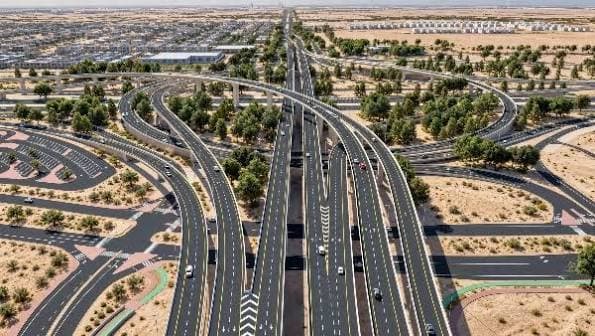
Abu Dhabi coastal highway plans will deliver a 37km expressway linking Al Hudayriyat Island with E11 at Al Nouf. The planned construction will create a direct coastal connection between Al Dhafra and Abu Dhabi Island.
It will cross several islands and incorporate extensive marine infrastructure. The route will provide an alternative corridor around central Abu Dhabi for freight and commuter traffic.
The Department of Municipalities and Transport (DMT) showcased the project during LIVEX 2026. The authority has not disclosed the project’s construction value or delivery schedule.
Abu Dhabi coastal highway brings major marine construction
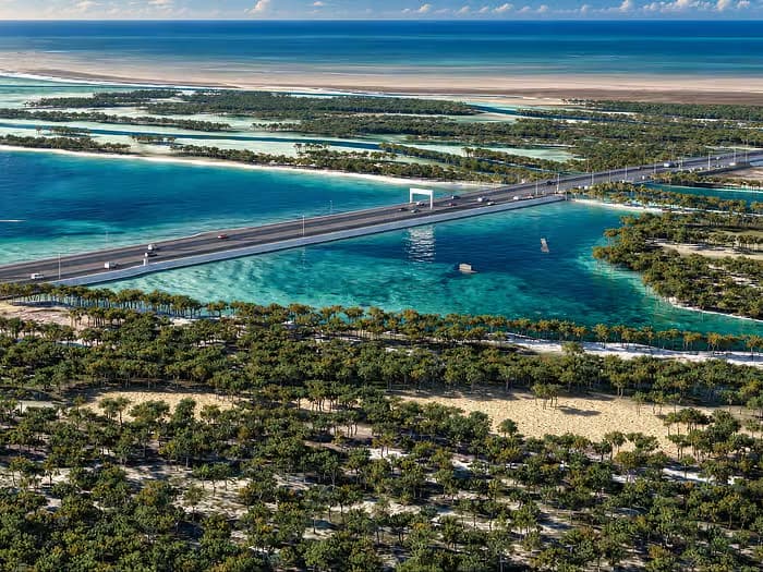
The Abu Dhabi coastal highway will feature three lanes in each direction across its 37km alignment. The project will include one tunnel, seven kilometers of marine bridges and four kilometers of causeways.
The route will connect Al Dhafra directly with Al Hudayriyat Island and Abu Dhabi Island. It will pass through Halat Al Bahrani, Al Futaisi and Al Aryam islands.
Therefore, the project will create a new strategic transport corridor across Abu Dhabi’s coastal landscape. It will also provide an alternative route around central-city traffic.
The seven kilometers of marine bridges represent a major structural component of the planned works. Meanwhile, four kilometers of causeways will carry the expressway across water-based sections.
The combination of bridges, causeways and a tunnel will require substantial marine and civil engineering. Road construction will then integrate these structures into the wider highway network.
The route will also support Abu Dhabi’s wider strategy of improving connections across its islands. DMT presented the project alongside other major transport infrastructure during LIVEX 2026.
Abu Dhabi coastal highway strengthens regional transport links
The Abu Dhabi coastal highway will serve commercial freight operators and everyday commuters. Consequently, the project could improve movement between western Abu Dhabi and the capital.
The coastal alignment will allow traffic to bypass central-city routes. This could provide an additional corridor for vehicles travelling between Al Dhafra and Abu Dhabi Island.
The project also differs from the AED2.85 billion Mid-Island Parkway. That separate development targets connections across Abu Dhabi’s central islands and has a 2027 first-phase completion target.
DMT has not assigned a public construction cost to the coastal highway. Therefore, no reliable US-dollar value can be attached to the project yet.
Importantly, the disclosed AED2.85 billion value belongs to the separate Mid-Island Parkway. It should not be attributed to the 37km coastal highway.
The coastal highway’s procurement strategy, contractor appointments and construction programme also remain undisclosed. Further announcements will clarify the project’s delivery arrangements.
Abu Dhabi is also advancing the Dh2.85-billion Mid-Island Parkway, an eight-lane road designed to strengthen connections between key islands. The project will link Saadiyat Island with Umm Yifeenah Island while cutting journeys to Reem Island and Abu Dhabi Island to about 10 minutes.
Abu Dhabi coastal highway incorporates environmental safeguards
The Abu Dhabi coastal highway will pass through environmentally sensitive coastal areas. The planned route includes safeguards around the Bul Syayeef Marine Protected Area and a Ramsar wetland.
The project will incorporate animal crossing infrastructure alongside its major transport works. These measures aim to limit impacts on surrounding marine and coastal environments.
The environmental provisions add another engineering consideration to the project’s extensive marine construction scope. Designers must balance transport connectivity with protection of sensitive habitats.
The route therefore combines road construction with bridges, causeways, tunneling and environmental protection. This combination makes the project a significant addition to Abu Dhabi’s infrastructure pipeline.
DMT has not announced a construction start date or completion target. The project remains at the planning stage as authorities develop the proposed coastal connection.
Project Fact Sheet
Name: Al Hudayriyat–Al Nouf Coastal Highway
Type: Coastal expressway and marine infrastructure
Location: Abu Dhabi, United Arab Emirates
Total route length: 37 kilometers
Road configuration: Three lanes in each direction
Northern connection: Al Hudayriyat Island
E11 connection: Al Nouf
Regional connection: Al Dhafra to Abu Dhabi Island
Route islands: Halat Al Bahrani, Al Futaisi and Al Aryam
Marine bridges: Seven kilometers
Causeways: Four kilometers
Tunnel: One
Primary purpose: Coastal bypass around central Abu Dhabi traffic
Main users: Commercial freight and everyday commuters
Environmental area: Bul Syayeef Marine Protected Area
Protected habitat: Ramsar wetland
Environmental measures: Animal crossing infrastructure and environmental safeguards
Construction status: Planned
Construction start: Not announced
Completion date: Not announced
Project cost: Not disclosed
Project Team
Authority: Department of Municipalities and Transport (DMT)
Planning: Department of Municipalities and Transport (DMT)
Infrastructure development: Department of Municipalities and Transport (DMT)
Transport planning: Department of Municipalities and Transport (DMT)
Coastal infrastructure planning: Department of Municipalities and Transport (DMT)
Environmental planning: Department of Municipalities and Transport (DMT)
Project presentation: Department of Municipalities and Transport (DMT)
Project showcase: Department of Municipalities and Transport (DMT), at LIVEX 2026
Engineering consultant: Not announced
Main contractor: Not announced
Marine works contractor: Not announced
Procurement status: No contractor award announced


Comments
No comments yet. Be the first to share your thoughts.