
Nairobi plans new public park along Kibagare River
Nairobi plans new public park along Kibagare River

The proposed green corridor will run from Westlands through Parklands to Ojijo Road, combining river restoration, public recreation and action against illegal structures.
Plans to transform the Kibagare River corridor into a continuous public park are nearing completion, with the Nairobi Rivers Commission and Nairobi City County Government working together to restore the waterway and create new public spaces.
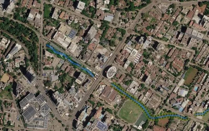
The proposed park will stretch from Westlands through Parklands towards Ojijo Road, with walking paths, landscaped green spaces and an open river channel forming part of the design.
According to the Westlands Park Scheme Design aerial plan reviewed by The Eastleigh Voice, the route begins west of Ring Road Westlands, near Sarit Centre and the Waiyaki Way interchange approaches.
From there, the green corridor will follow the river south-east past Muthithi Road, Mpaka Road and Parklands Road, near The Oval. It will continue alongside the Aga Khan Sports Club grounds towards First Parklands Avenue.
The project is part of a wider effort to reclaim riverbanks, improve the environment and provide residents with accessible public spaces.
The design features an open, natural river channel surrounded by a continuous green buffer zone. Plans include planting indigenous trees, creating pedestrian walkways and providing public park facilities.
Latest Stories
- African countries could save billions by cutting air pollution and greenhouse gases at the same time
- Nominated Senator Crystal Asige joins Winnie Odinga and Jalang’o in Nairobi Senate race
- Tusker FC suffer home defeat as Singida strike puts CAF Confederation Cup hopes at risk
- Ecuadorian priest dies after giant wooden crucifix crashes down on him during live-streamed Mass
The designated river control zone will extend between 30 and 60 metres from the riverbanks. However, the exact amount of land to be used for the park will depend on field surveys that are still underway.
A major part of the project will involve removing sections of the river that have been channelled through pipes or covered by buildings and other structures. These include areas within commercial and residential developments, as well as the Oshwal Religious Centre complex.
Opening up these sections is expected to help restore the river's natural course and address blockages along the waterway.
The Oshwal Religious Centre Committee, led by chairman Samir Chandaria, met the multi-agency team on Friday, 16 October, and pledged to support the proposed river restoration and park development.
Authorities have also held consultations with residents of Parklands Court, Brookside Drive, Grevillea Grove and Ndovu Lane.
Notices have been issued requiring the removal of structures built directly over the river, as the agencies seek to reopen sections of the waterway and establish the boundaries of the proposed park.
Authorities and estate representatives have also begun a joint exercise to re-demarcate the river corridor. The exercise aims to establish the waterway's original alignment and address long-standing bottlenecks caused by culverts along First Parklands Avenue.
The Parklands Residents Association has directed affected landowners within the river corridor to submit official property documents to the Nairobi Rivers Commission at Ardhi House for technical review.
The process is expected to help establish property boundaries and clarify which sections fall within the designated river reserve.
The initiative brings together environmental restoration, enforcement against illegal riverbank developments and the creation of public recreational facilities.
The Kibagare River park proposal forms part of broader Nairobi River regeneration programmes estimated at Sh50 billion.
The wider plans aim to improve river health, control pollution and develop public spaces, including walking and cycling routes that encourage non-motorised transport.



Comments
No comments yet. Be the first to share your thoughts.